Have you signed in?
You are currently not signed in to your account. Sign in to track service requests.
If you are using a public computer, remember to sign out when you are finished.
Would you like to register for an account?
You can follow our easy, online registration process to create an account to track service requests.
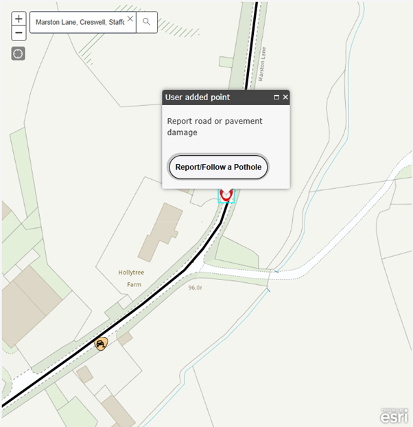
How to use the new ReportIt System
- This form can be used to report several issues. Please see below for what you can report. Some issues may need another form, or you may need to contact another authority or organisation
- Click "Begin this form" at the bottom of the page which will take you to a map to plot the location of your issue
- Zoom in/out for a location or use the search facility in the top left corner of the map
- Once you have located your issue, plot a point where this is on the map
- The point will be displayed by a red icon and a popup with "User Added Point"
- In the popup, click on "Report/Follow a ..." to move to the next step (Pictured)
- The next pages will ask you to provide further details, photos and finally your contact information, which we will use to provide you with updates about the issue you have raised
Map Example
About this form
In this section, you can report the following issues:
- Overgrown grass, trees, hedges or weeds
- Fallen tree or large branch
- Roots cause damage
- Grass which has been driven over
To report a different issue, please click the button below.
Before starting this form
There are some areas that fall outside of our responsibility. These include:
- Roads outside of Staffordshire's boundary
- Major roads such as M6, M54, A38, A50 and A500, Contact National Highways
- Canal towpaths, Contact Canal & River trust
- Private or unadopted roads
To continue making a report, please click the button below.
Latest Cases – Grass Trees Weeds
| Reference | Case Type | Enquiry Type | Status | Created | Street | Town |
|---|---|---|---|---|---|---|
| GTW006631 | Grass Trees Weeds | Fallen Tree | Enquiry raised | 21/06/2026 17:15 | PENARTH PLACE | NEWCASTLE UNDER LYME |
| GTW006630 | Grass Trees Weeds | Fallen Tree | Enquiry raised | 21/06/2026 12:13 | BELFORT WAY | STAFFORD |
| GTW006629 | Grass Trees Weeds | Overgrown Hedge | Enquiry raised | 21/06/2026 09:03 | LINK FOOTWAY FROM CHAIN LANE TO HUNTERS | STAFFORD |
| GTW006628 | Grass Trees Weeds | Overgrown Hedge | Enquiry raised | 21/06/2026 05:57 | COPPICE ROAD | NEWCASTLE UNDER LYME |
| GTW006627 | Grass Trees Weeds | Fallen Tree | Enquiry raised | 21/06/2026 04:40 | RUE HILL ROAD | STANTON DALE |
| GTW006626 | Grass Trees Weeds | Fallen Tree | Enquiry raised | 20/06/2026 22:11 | PENKRIDGE BANK ROAD | RUGELEY |
| GTW006625 | Grass Trees Weeds | Fallen Tree | Enquiry raised | 20/06/2026 22:06 | BROADHURST GREEN ROAD | BROADHURST GREEN |
| GTW006624 | Grass Trees Weeds | Overgrown Hedge | Enquiry raised | 20/06/2026 19:31 | CURZON STREET | NEWCASTLE UNDER LYME |
| GTW006623 | Grass Trees Weeds | Verge Hazard | Enquiry raised | 20/06/2026 17:31 | SWAN ROAD | DRAYCOTT IN THE CLAY |
| GTW006622 | Grass Trees Weeds | Verge Hazard | Enquiry raised | 20/06/2026 17:30 | COMMON ROAD | WOMBOURNE |
| GTW006621 | Grass Trees Weeds | Overgrown Hedge | Enquiry raised | 20/06/2026 15:55 | MOOR LANE | PATTINGHAM |
| GTW006620 | Grass Trees Weeds | Overgrown Hedge | Enquiry raised | 20/06/2026 15:31 | ROMAN COURT | TAMWORTH |
| GTW006619 | Grass Trees Weeds | Fallen Tree | Enquiry raised | 20/06/2026 15:04 | MILL LANE | MILL GREEN |
| GTW006618 | Grass Trees Weeds | Overgrown Hedge | Enquiry raised | 20/06/2026 15:03 | THE PARKWAY | PERTON |
| GTW006617 | Grass Trees Weeds | Verge Hazard | Enquiry raised | 20/06/2026 10:28 | TRENT VALLEY ROAD | LICHFIELD |
| GTW006616 | Grass Trees Weeds | Fallen Tree | Enquiry raised | 20/06/2026 09:44 | RUGELEY ROAD | CANNOCK |
| GTW006615 | Grass Trees Weeds | Fallen Tree | Work raised - enquiry closed | 20/06/2026 09:05 | SHAKESPEARE ROAD | BURNTWOOD |
| GTW006614 | Grass Trees Weeds | Overgrown Hedge | Enquiry raised | 20/06/2026 08:26 | DERBY ROAD | STRETTON |
| GTW006613 | Grass Trees Weeds | Overgrown Hedge | Enquiry raised | 19/06/2026 22:24 | WOLVERHAMPTON ROAD | CHESLYN HAY |
| GTW006612 | Grass Trees Weeds | Fallen Tree | Enquiry raised | 19/06/2026 22:01 | CROXALL ROAD | ALREWAS |
| GTW006611 | Grass Trees Weeds | Fallen Tree | Enquiry raised | 19/06/2026 19:59 | HUGO STREET | LEEK |
| GTW006610 | Grass Trees Weeds | Fallen Tree | Enquiry raised | 19/06/2026 19:31 | WOOD ROAD | CODSALL |
| GTW006609 | Grass Trees Weeds | Fallen Tree | Enquiry raised | 19/06/2026 17:06 | DERBY ROAD | STRETTON |
| GTW006608 | Grass Trees Weeds | Fallen Tree | Enquiry raised | 19/06/2026 17:01 | LYNN LANE | SHENSTONE |
| GTW006607 | Grass Trees Weeds | Fallen Tree | Enquiry raised | 19/06/2026 16:26 | WOOD ROAD | CODSALL |
| GTW006606 | Grass Trees Weeds | Pavement / Cycleway Weed Growth | Enquiry raised | 19/06/2026 16:23 | NORTHWOOD LANE | CLAYTON |
| GTW006605 | Grass Trees Weeds | Pavement / Cycleway Weed Growth | Enquiry raised | 19/06/2026 16:12 | HOLLYHURST | STAFFORD |
| GTW006604 | Grass Trees Weeds | Fallen Tree | Enquiry raised | 19/06/2026 16:04 | LINK FOOTWAY FROM HAYES WAY TO ATTINGHAM | CANNOCK |
| GTW006603 | Grass Trees Weeds | Overgrown Hedge | Enquiry raised | 19/06/2026 15:22 | JUNCTION ROAD | LEEK |
| GTW006602 | Grass Trees Weeds | Fallen Tree | Enquiry raised | 19/06/2026 15:14 | BRADWELL LANE | NEWCASTLE UNDER LYME |
| GTW006601 | Grass Trees Weeds | Tree / Hedge | Enquiry raised | 19/06/2026 14:41 | CLARE AVENUE | NEWCASTLE UNDER LYME |
| GTW006600 | Grass Trees Weeds | Fallen Tree | Enquiry raised | 19/06/2026 14:27 | LYNN LANE | SHENSTONE |
| GTW006599 | Grass Trees Weeds | Pavement / Cycleway Weed Growth | Enquiry raised | 19/06/2026 14:14 | GRIFFIN CLOSE | BURNTWOOD |
| GTW006598 | Grass Trees Weeds | Pavement / Cycleway Weed Growth | Enquiry raised | 19/06/2026 14:03 | LITTLEWORTH ROAD | CANNOCK |
| GTW006597 | Grass Trees Weeds | Fallen Tree | Enquiry raised | 19/06/2026 13:42 | WOODCROFT ROAD | LEEK |
| GTW006596 | Grass Trees Weeds | Fallen Tree | Enquiry raised | 19/06/2026 13:05 | LINK FOOTWAY FROM 54 TO 63 CALDER | TAMWORTH |
| GTW006595 | Grass Trees Weeds | Overgrown Hedge | Enquiry raised | 19/06/2026 11:25 | GREEN HEATH ROAD | CANNOCK |
| GTW006594 | Grass Trees Weeds | Overgrown Hedge | Enquiry raised | 19/06/2026 10:57 | STAPENHILL ROAD | BURTON UPON TRENT |
| GTW006593 | Grass Trees Weeds | Overgrown Hedge | Enquiry raised | 19/06/2026 10:54 | PARKING OFF ACCESS ROAD TO DEVEREUX HOUS | |
| GTW006592 | Grass Trees Weeds | Verge Hazard | Enquiry raised | 19/06/2026 09:50 | ALCESTER ROW | STAFFORD |
| GTW006591 | Grass Trees Weeds | Overgrown Hedge | Enquiry raised | 19/06/2026 09:42 | SHOBNALL ROAD | BURTON UPON TRENT |
| GTW006590 | Grass Trees Weeds | Overgrown Hedge | Enquiry raised | 19/06/2026 09:28 | PARKWAY | BURTON UPON TRENT |
| GTW006589 | Grass Trees Weeds | Overgrown Hedge | Enquiry raised | 18/06/2026 23:01 | LINK FOOTWAY FROM WIMBERRY DRIVE TO PUBL | NEWCASTLE UNDER LYME |
| GTW006588 | Grass Trees Weeds | Fallen Tree | Enquiry raised | 18/06/2026 22:24 | ROWTON STREET | BURTON UPON TRENT |
| GTW006587 | Grass Trees Weeds | Fallen Tree | No action required - enquiry closed | 18/06/2026 20:00 | STONE ROAD | UTTOXETER |
| GTW006586 | Grass Trees Weeds | Verge Hazard | Enquiry raised | 18/06/2026 20:00 | HILL TOP | CANNOCK |
| GTW006585 | Grass Trees Weeds | Tree Damaged | Enquiry raised | 18/06/2026 17:54 | CAPTAINS LANE | BARTON UNDER NEEDWOOD |
| GTW006584 | Grass Trees Weeds | Overgrown Hedge | Enquiry raised | 18/06/2026 16:43 | SMITHFIELD ROAD | UTTOXETER |
| GTW006583 | Grass Trees Weeds | Fallen Tree | Enquiry raised | 18/06/2026 16:07 | TUTBURY ROAD | BURTON UPON TRENT |
| GTW006582 | Grass Trees Weeds | Fallen Tree | Enquiry raised | 18/06/2026 14:57 | SALT AVENUE | STAFFORD |
| GTW006581 | Grass Trees Weeds | Fallen Tree | Enquiry raised | 18/06/2026 14:43 | TRENT VALLEY ROAD | LICHFIELD |
| GTW006580 | Grass Trees Weeds | Fallen Tree | Enquiry raised | 18/06/2026 14:33 | TRENT VALLEY ROAD | LICHFIELD |
| GTW006579 | Grass Trees Weeds | Overgrown Hedge | Enquiry raised | 18/06/2026 14:31 | STONYDELPH LANE CYCLEWAY | TAMWORTH |
| GTW006578 | Grass Trees Weeds | Fallen Tree | Enquiry raised | 18/06/2026 13:53 | PUMP LANE | RUGELEY |
| GTW006577 | Grass Trees Weeds | Fallen Tree | Enquiry raised | 18/06/2026 13:51 | PUMP LANE | RUGELEY |
| GTW006576 | Grass Trees Weeds | Fallen Tree | Enquiry raised | 18/06/2026 13:48 | PUMP LANE | RUGELEY |
| GTW006575 | Grass Trees Weeds | Fallen Tree | Enquiry raised | 18/06/2026 13:46 | PUMP LANE | RUGELEY |
| GTW006574 | Grass Trees Weeds | Fallen Tree | Enquiry raised | 18/06/2026 13:43 | PUMP LANE | RUGELEY |
| GTW006573 | Grass Trees Weeds | Verge Hazard | Enquiry raised | 18/06/2026 13:09 | PARK ROAD | BARTON UNDER NEEDWOOD |
| GTW006572 | Grass Trees Weeds | Verge Hazard | Enquiry raised | 18/06/2026 13:03 | HIMLEY LANE | SWINDON |
| GTW006571 | Grass Trees Weeds | Pavement / Cycleway Weed Growth | Enquiry raised | 18/06/2026 12:56 | LINK FOOTWAY FROM SANDON ROAD TO CORONAT | STAFFORD |
| GTW006570 | Grass Trees Weeds | Fallen Tree | Enquiry raised | 18/06/2026 12:51 | THE ISABEL TRAIL | STAFFORD |
| GTW006569 | Grass Trees Weeds | Fallen Tree | Enquiry raised | 18/06/2026 12:50 | COULTHWAITE WAY | RUGELEY |
| GTW006568 | Grass Trees Weeds | Overgrown Hedge | Enquiry raised | 18/06/2026 12:05 | BEARNETT DRIVE | LLOYD HILL |
| GTW006567 | Grass Trees Weeds | Overgrown Hedge | Enquiry raised | 18/06/2026 11:52 | NEWCASTLE ROAD | LEEK |
| GTW006566 | Grass Trees Weeds | Overgrown Hedge | Enquiry raised | 18/06/2026 11:48 | JUNCTION ROAD | LEEK |
| GTW006565 | Grass Trees Weeds | Overgrown Hedge | Enquiry raised | 18/06/2026 11:43 | NEW ROAD | PENKRIDGE |
| GTW006564 | Grass Trees Weeds | Overgrown Hedge | Enquiry raised | 18/06/2026 10:56 | A51 LINK ROAD FROM A513 TO MAIN ROAD | ARMITAGE |
| GTW006563 | Grass Trees Weeds | Overgrown Hedge | Enquiry raised | 18/06/2026 10:39 | BARBRIDGE ROAD | NEWCASTLE UNDER LYME |
| GTW006562 | Grass Trees Weeds | Fallen Tree | No action required - enquiry closed | 18/06/2026 10:04 | BEASLEY AVENUE | NEWCASTLE UNDER LYME |
| GTW006561 | Grass Trees Weeds | Verge Hazard | Enquiry raised | 18/06/2026 09:51 | MOSSFIELD DRIVE | BIDDULPH |
| GTW006560 | Grass Trees Weeds | Overgrown Hedge | Enquiry raised | 18/06/2026 09:33 | GOSPEL END ROAD | GOSPEL END |
| GTW006559 | Grass Trees Weeds | Fallen Tree | Enquiry raised | 18/06/2026 09:19 | HEMPSTALLS LANE | NEWCASTLE UNDER LYME |
| GTW006558 | Grass Trees Weeds | Overgrown Hedge | Enquiry raised | 18/06/2026 09:15 | HOLLINGTON ROAD | CROXDEN |
| GTW006557 | Grass Trees Weeds | Fallen Tree | Enquiry raised | 18/06/2026 08:23 | LUD LANE | TAMWORTH |
| GTW006556 | Grass Trees Weeds | Fallen Tree | Enquiry raised | 17/06/2026 21:21 | CELLARHEAD ROAD | CELLARHEAD |
| GTW006555 | Grass Trees Weeds | Overgrown Hedge | Enquiry raised | 17/06/2026 20:51 | LINK FOOTWAY AT SIDE OF 21 QUINCE | TAMWORTH |
| GTW006554 | Grass Trees Weeds | Tree Damaged | Enquiry raised | 17/06/2026 20:28 | HOLYHEAD ROAD | CODSALL |
| GTW006553 | Grass Trees Weeds | Fallen Tree | Enquiry raised | 17/06/2026 18:59 | WOOD ROAD | CODSALL |
| GTW006552 | Grass Trees Weeds | Tree Damaged | Enquiry raised | 17/06/2026 18:56 | WOOD ROAD | CODSALL |
| GTW006551 | Grass Trees Weeds | Verge Hazard | Enquiry raised | 17/06/2026 18:39 | HAYES WAY | CANNOCK |
| GTW006550 | Grass Trees Weeds | Fallen Tree | No action required - enquiry closed | 17/06/2026 18:29 | HAIG ROAD | LEEK |
| GTW006549 | Grass Trees Weeds | Fallen Tree | Enquiry raised | 17/06/2026 18:29 | TAMWORTH ROAD | TAMWORTH |
| GTW006548 | Grass Trees Weeds | Fallen Tree | No action required - enquiry closed | 17/06/2026 18:24 | HAIG ROAD | LEEK |
| GTW006547 | Grass Trees Weeds | Fallen Tree | No action required - enquiry closed | 17/06/2026 18:18 | HAIG ROAD | LEEK |
| GTW006546 | Grass Trees Weeds | Fallen Tree | No action required - enquiry closed | 17/06/2026 18:12 | HAIG ROAD | LEEK |
| GTW006545 | Grass Trees Weeds | Fallen Tree | No action required - enquiry closed | 17/06/2026 18:08 | HAIG ROAD | LEEK |
| GTW006544 | Grass Trees Weeds | Fallen Tree | No action required - enquiry closed | 17/06/2026 18:03 | HAIG ROAD | LEEK |
| GTW006543 | Grass Trees Weeds | Verge Hazard | Enquiry raised | 17/06/2026 17:50 | CAMP ROAD | LITTLE HAY |
| GTW006542 | Grass Trees Weeds | Fallen Tree | Job complete - enquiry closed | 17/06/2026 17:05 | A513 ALREWAS BYPASS FROM KINGS BROMLEY R | ALREWAS |
| GTW006541 | Grass Trees Weeds | Fallen Tree | Enquiry raised | 17/06/2026 17:00 | BUCKMASTER AVENUE | NEWCASTLE UNDER LYME |
| GTW006540 | Grass Trees Weeds | Verge Hazard | Enquiry raised | 17/06/2026 16:13 | LINK FOOTWAY AT SIDE OF HOUSE NUMBER 15 | BILBROOK |
| GTW006539 | Grass Trees Weeds | Verge Hazard | Enquiry raised | 17/06/2026 15:08 | LINK FOOTWAY FROM HAYES WAY TO ATTINGHAM | CANNOCK |
| GTW006538 | Grass Trees Weeds | Pavement / Cycleway Weed Growth | Enquiry raised | 17/06/2026 14:32 | WATERSIDE ROAD | BURTON UPON TRENT |
| GTW006537 | Grass Trees Weeds | Overgrown Hedge | Enquiry raised | 17/06/2026 14:28 | STURGEONS HILL | LICHFIELD |
| GTW006536 | Grass Trees Weeds | Fallen Tree | Enquiry raised | 17/06/2026 14:26 | STONYDELPH LANE CYCLEWAY | TAMWORTH |
| GTW006535 | Grass Trees Weeds | Pavement / Cycleway Weed Growth | Enquiry raised | 17/06/2026 14:24 | EDGAR CLOSE | TAMWORTH |
| GTW006534 | Grass Trees Weeds | Fallen Tree | Enquiry raised | 17/06/2026 14:01 | SILVER LINK ROAD | TAMWORTH |
| GTW006533 | Grass Trees Weeds | Overgrown Hedge | Enquiry raised | 17/06/2026 13:39 | LINK FOOTWAY FROM KINGSWEAR AVENUE TO FA | PERTON |
| GTW006532 | Grass Trees Weeds | Verge Hazard | Enquiry raised | 17/06/2026 13:21 | THE FILLYBROOKS | STONE |
| GTW006531 | Grass Trees Weeds | Fallen Tree | Enquiry raised | 17/06/2026 13:19 | FRIARSWOOD ROAD | NEWCASTLE UNDER LYME |
| GTW006530 | Grass Trees Weeds | Overgrown Hedge | Enquiry raised | 17/06/2026 12:47 | CRAWLEY LANE | KINGS BROMLEY |
| GTW006529 | Grass Trees Weeds | Fallen Tree | Enquiry raised | 17/06/2026 12:23 | LINK FOOTWAY SOUTH OF THACKERAY WALK | STAFFORD |
| GTW006528 | Grass Trees Weeds | Verge Hazard | Enquiry raised | 17/06/2026 12:19 | WOLVERHAMPTON ROAD | PRESTWOOD |
| GTW006527 | Grass Trees Weeds | Overgrown Hedge | Enquiry raised | 17/06/2026 12:03 | GLASCOTE ROAD | GLASCOTE |
| GTW006526 | Grass Trees Weeds | Fallen Tree | Enquiry raised | 17/06/2026 11:43 | CHASELEY ROAD | RUGELEY |
| GTW006525 | Grass Trees Weeds | Fallen Tree | Enquiry raised | 17/06/2026 11:29 | BERESFORD CRESCENT | NEWCASTLE UNDER LYME |
| GTW006524 | Grass Trees Weeds | Fallen Tree | No action required - enquiry closed | 17/06/2026 10:51 | RUDYARD ROAD | BENTHEAD |
| GTW006523 | Grass Trees Weeds | Overgrown Hedge | Enquiry raised | 17/06/2026 10:26 | MILLMOOR AVENUE | ARMITAGE |
| GTW006522 | Grass Trees Weeds | Verge Hazard | Enquiry raised | 17/06/2026 10:06 | HIGH STREET | KINVER |
| GTW006521 | Grass Trees Weeds | Pavement / Cycleway Weed Growth | Enquiry raised | 17/06/2026 09:41 | BLYTHE STREET | TAMWORTH |
| GTW006520 | Grass Trees Weeds | Fallen Tree | Work raised - enquiry closed | 17/06/2026 09:31 | BURY BANK | DARLASTON |
| GTW006519 | Grass Trees Weeds | Fallen Tree | Job complete - enquiry closed | 17/06/2026 09:30 | STONE ROAD | TITTENSOR |
| GTW006518 | Grass Trees Weeds | Fallen Tree | No action required - enquiry closed | 17/06/2026 07:17 | ASHBOURNE ROAD | CHEADLE |
| GTW006517 | Grass Trees Weeds | Verge Hazard | Enquiry raised | 16/06/2026 23:03 | PENN CROFT LANE | PENN COMMON |
| GTW006516 | Grass Trees Weeds | Verge Hazard | Enquiry raised | 16/06/2026 21:11 | HOLLOW LANE | DRAYCOTT IN THE CLAY |
| GTW006515 | Grass Trees Weeds | Fallen Tree | No action required - enquiry closed | 16/06/2026 21:03 | HILLPORT AVENUE | NEWCASTLE UNDER LYME |
| GTW006514 | Grass Trees Weeds | Verge Hazard | Enquiry raised | 16/06/2026 17:23 | TAYLOR AVENUE | NEWCASTLE UNDER LYME |
| GTW006513 | Grass Trees Weeds | Fallen Tree | Enquiry raised | 16/06/2026 16:53 | MAYER AVENUE | NEWCASTLE UNDER LYME |
| GTW006512 | Grass Trees Weeds | Overgrown Hedge | Enquiry raised | 16/06/2026 16:14 | MAYER AVENUE | NEWCASTLE UNDER LYME |
| GTW006511 | Grass Trees Weeds | Verge Hazard | Enquiry raised | 16/06/2026 14:41 | WHEELOCK WAY | NEWCASTLE UNDER LYME |
| GTW006510 | Grass Trees Weeds | Overgrown Hedge | Enquiry raised | 16/06/2026 14:20 | FROGHALL ROAD | CHEADLE |
| GTW006509 | Grass Trees Weeds | Fallen Tree | Enquiry raised | 16/06/2026 13:58 | WHITBY CLOSE | STAFFORD |
| GTW006508 | Grass Trees Weeds | Verge Hazard | Enquiry raised | 16/06/2026 13:55 | STONE ROAD | TITTENSOR |
| GTW006507 | Grass Trees Weeds | Verge Hazard | Enquiry raised | 16/06/2026 13:40 | CHASE LANE | TITTENSOR |
| GTW006506 | Grass Trees Weeds | Verge Hazard | Enquiry raised | 16/06/2026 12:58 | BEACON RISE | STONE |
| GTW006505 | Grass Trees Weeds | Fallen Tree | Enquiry raised | 16/06/2026 12:43 | LINK FOOTWAY FROM THE PARKWAY TO SEVERN | PERTON |
| GTW006504 | Grass Trees Weeds | Overgrown Hedge | Enquiry raised | 16/06/2026 12:24 | ST MICHAELS MOUNT | STONE |
| GTW006503 | Grass Trees Weeds | Overgrown Hedge | Enquiry raised | 16/06/2026 12:00 | SUTTON ROAD | CARROWAY HEAD |
| GTW006502 | Grass Trees Weeds | Fallen Tree | Enquiry raised | 16/06/2026 11:58 | ASHBOURNE ROAD | LEEK |
| GTW006501 | Grass Trees Weeds | Fallen Tree | No action required - enquiry closed | 16/06/2026 11:19 | MEAFORD AVENUE | STONE |
| GTW006500 | Grass Trees Weeds | Overgrown Hedge | Enquiry raised | 16/06/2026 11:17 | MICKLEHOME DRIVE | ALREWAS |
| GTW006499 | Grass Trees Weeds | Overgrown Hedge | Enquiry raised | 16/06/2026 11:09 | STATION ROAD | PENKRIDGE |
| GTW006498 | Grass Trees Weeds | Overgrown Hedge | Enquiry raised | 16/06/2026 10:12 | BELMOT ROAD | TUTBURY |
| GTW006497 | Grass Trees Weeds | Verge Hazard | Enquiry raised | 16/06/2026 09:57 | MEAD CRESCENT | BURTON UPON TRENT |
| GTW006496 | Grass Trees Weeds | Overgrown Hedge | Enquiry raised | 16/06/2026 09:50 | FIELD STREET | CANNOCK |
| GTW006495 | Grass Trees Weeds | Verge Hazard | Enquiry raised | 16/06/2026 09:43 | LINK FOOTWAY AT SIDE OF 14 HILLCREST CLO | TAMWORTH |
| GTW006494 | Grass Trees Weeds | Verge Hazard | Enquiry raised | 16/06/2026 09:17 | LONG STREET | WHEATON ASTON |
| GTW006493 | Grass Trees Weeds | Overgrown Hedge | Enquiry raised | 16/06/2026 09:10 | TALBOT STREET BACK ROAD | RUGELEY |
| GTW006492 | Grass Trees Weeds | Overgrown Hedge | Enquiry raised | 16/06/2026 09:04 | UTTOXETER ROAD | STOKE-ON-TRENT |
| GTW006491 | Grass Trees Weeds | Fallen Tree | Enquiry raised | 16/06/2026 08:20 | PRIORY ROAD | NEWCASTLE UNDER LYME |
| GTW006490 | Grass Trees Weeds | Fallen Tree | Enquiry raised | 16/06/2026 07:48 | KEELE ROAD | NEWCASTLE UNDER LYME |
| GTW006489 | Grass Trees Weeds | Fallen Tree | Enquiry raised | 16/06/2026 06:42 | SPODE AVENUE | RUGELEY |
| GTW006488 | Grass Trees Weeds | Fallen Tree | No action required - enquiry closed | 16/06/2026 05:45 | PORTAL ROAD | STAFFORD |
| GTW006487 | Grass Trees Weeds | Fallen Tree | Enquiry raised | 15/06/2026 22:59 | MARKET DRAYTON ROAD | BLOREHEATH |
| GTW006486 | Grass Trees Weeds | Fallen Tree | Enquiry raised | 15/06/2026 21:38 | BROAD LANE | SPRINGHILL |
| GTW006485 | Grass Trees Weeds | Pavement / Cycleway Weed Growth | Enquiry raised | 15/06/2026 21:11 | BILBERRY CRESCENT | HUNTINGTON |
| GTW006484 | Grass Trees Weeds | Overgrown Hedge | Enquiry raised | 15/06/2026 20:38 | WOLVERHAMPTON ROAD | PENKRIDGE |
| GTW006483 | Grass Trees Weeds | Overgrown Hedge | Enquiry raised | 15/06/2026 19:06 | HIGH GRANGE | LICHFIELD |
| GTW006482 | Grass Trees Weeds | Fallen Tree | Enquiry raised | 15/06/2026 18:26 | ST ANNES VALE | BROWN EDGE |
| GTW006481 | Grass Trees Weeds | Overgrown Hedge | Enquiry raised | 15/06/2026 17:51 | HARBURY STREET | BURTON UPON TRENT |
| GTW006480 | Grass Trees Weeds | Verge Hazard | Enquiry raised | 15/06/2026 17:39 | STOWE STREET | LICHFIELD |
| GTW006479 | Grass Trees Weeds | Fallen Tree | No action required - enquiry closed | 15/06/2026 16:37 | TRENT VALLEY ROAD | LICHFIELD |
| GTW006478 | Grass Trees Weeds | Overgrown Hedge | Enquiry raised | 15/06/2026 16:35 | MUSTANG DRIVE | STAFFORD |
| GTW006477 | Grass Trees Weeds | Fallen Tree | Enquiry raised | 15/06/2026 16:30 | NEWCASTLE ROAD | STONE |
| GTW006476 | Grass Trees Weeds | Fallen Tree | Enquiry raised | 15/06/2026 16:28 | NEWCASTLE ROAD | STONE |
| GTW006475 | Grass Trees Weeds | Fallen Tree | Enquiry raised | 15/06/2026 16:27 | BEACON RISE | STONE |
| GTW006474 | Grass Trees Weeds | Fallen Tree | Enquiry raised | 15/06/2026 16:25 | BROOMS SERVICE ROAD | STONE |
| GTW006473 | Grass Trees Weeds | Fallen Tree | Enquiry raised | 15/06/2026 16:21 | BEACON ROAD | STONE |
| GTW006472 | Grass Trees Weeds | Fallen Tree | Enquiry raised | 15/06/2026 16:13 | CLUMBER AVENUE | NEWCASTLE UNDER LYME |
| GTW006471 | Grass Trees Weeds | Verge Hazard | No action required - enquiry closed | 15/06/2026 16:05 | WINDSOR ROAD | WOMBOURNE |
| GTW006470 | Grass Trees Weeds | Verge Hazard | Enquiry raised | 15/06/2026 16:03 | BRAMBER DRIVE | WOMBOURNE |
| GTW006469 | Grass Trees Weeds | Overgrown Hedge | Enquiry raised | 15/06/2026 15:50 | TAMWORTH ROAD | LICHFIELD |
| GTW006468 | Grass Trees Weeds | Fallen Tree | Enquiry raised | 15/06/2026 15:38 | ANGELICA | TAMWORTH |
| GTW006467 | Grass Trees Weeds | Verge Hazard | Enquiry raised | 15/06/2026 15:26 | MOUNT PLEASANT | NEWCASTLE UNDER LYME |
| GTW006466 | Grass Trees Weeds | Fallen Tree | No action required - enquiry closed | 15/06/2026 15:21 | HAIG ROAD | LEEK |
| GTW006465 | Grass Trees Weeds | Overgrown Hedge | Enquiry raised | 15/06/2026 15:15 | CANNOCK ROAD | CANNOCK |
| GTW006464 | Grass Trees Weeds | Overgrown Hedge | Enquiry raised | 15/06/2026 15:12 | LINK FOOTWAY FROM HAYES WAY TO ATTINGHAM | CANNOCK |
| GTW006463 | Grass Trees Weeds | Fallen Tree | Enquiry raised | 15/06/2026 15:06 | LINK FOOTWAY AT SIDE OF 4 BUCKDEN | TAMWORTH |
| GTW006462 | Grass Trees Weeds | Fallen Tree | Enquiry raised | 15/06/2026 14:47 | CYCLEWAY LINK FROM NEAR LOOMER ROAD TO C | NEWCASTLE UNDER LYME |
| GTW006461 | Grass Trees Weeds | Fallen Tree | Enquiry raised | 15/06/2026 14:42 | DUNSLEY ROAD | KINVER |
| GTW006459 | Grass Trees Weeds | Fallen Tree | Enquiry raised | 15/06/2026 13:40 | HORSLEY ROAD | ELFORD HEATH |
| GTW006458 | Grass Trees Weeds | Fallen Tree | Enquiry raised | 15/06/2026 13:32 | KERRY LANE | ELFORD HEATH |
| GTW006457 | Grass Trees Weeds | Fallen Tree | Enquiry raised | 15/06/2026 13:32 | MENDIP AVENUE | STAFFORD |
| GTW006456 | Grass Trees Weeds | Overgrown Hedge | Enquiry raised | 15/06/2026 13:25 | KERRY LANE | ELFORD HEATH |
| GTW006455 | Grass Trees Weeds | Verge Hazard | Enquiry raised | 15/06/2026 13:21 | LAMPREY | TAMWORTH |
| GTW006454 | Grass Trees Weeds | Fallen Tree | Enquiry raised | 15/06/2026 13:12 | KERRY LANE | ELFORD HEATH |
| GTW006453 | Grass Trees Weeds | Fallen Tree | No action required - enquiry closed | 15/06/2026 13:04 | KERRY LANE | ELFORD HEATH |
| GTW006452 | Grass Trees Weeds | Fallen Tree | No action required - enquiry closed | 15/06/2026 12:25 | PEAK CLOSE | HANDSACRE |
| GTW006451 | Grass Trees Weeds | Fallen Tree | No action required - enquiry closed | 15/06/2026 12:06 | ALLIANCE STREET | STAFFORD |
| GTW006450 | Grass Trees Weeds | Fallen Tree | Enquiry raised | 15/06/2026 11:56 | BITTERSCOTE LANE | TAMWORTH |
| GTW006449 | Grass Trees Weeds | Pavement / Cycleway Weed Growth | Job complete - enquiry closed | 15/06/2026 11:51 | HARTINGTON STREET | LEEK |
| GTW006448 | Grass Trees Weeds | Fallen Tree | Enquiry raised | 15/06/2026 11:47 | SILVER LINK ROAD | TAMWORTH |
| GTW006447 | Grass Trees Weeds | Overgrown Hedge | Enquiry raised | 15/06/2026 11:36 | FOOTWAY JUNCTION OF ST BRIDES CLOSE ADJA | WOMBOURNE |
| GTW006446 | Grass Trees Weeds | Fallen Tree | Enquiry raised | 15/06/2026 11:11 | TUTBURY BYPASS | TUTBURY |
| GTW006445 | Grass Trees Weeds | Tree Damaged | Enquiry raised | 15/06/2026 10:47 | SPOT GRANGE LANE | HILDERSTONE |
| GTW006444 | Grass Trees Weeds | Overgrown Hedge | Enquiry raised | 15/06/2026 10:38 | PRINCESS WAY | BURTON UPON TRENT |
| GTW006443 | Grass Trees Weeds | Fallen Tree | Enquiry raised | 15/06/2026 10:25 | UPPER GUNGATE | TAMWORTH |
| GTW006442 | Grass Trees Weeds | Fallen Tree | Enquiry raised | 15/06/2026 10:18 | THISTLEBERRY AVENUE | NEWCASTLE UNDER LYME |
| GTW006441 | Grass Trees Weeds | Fallen Tree | Enquiry raised | 15/06/2026 10:18 | ASHBOURNE ROAD | LEEK |
| GTW006440 | Grass Trees Weeds | Fallen Tree | Enquiry raised | 15/06/2026 10:12 | BUXTON ROAD | RAMSHAW |
| GTW006439 | Grass Trees Weeds | Fallen Tree | Enquiry raised | 15/06/2026 10:10 | RENE ROAD | TAMWORTH |
| GTW006438 | Grass Trees Weeds | Fallen Tree | Enquiry raised | 15/06/2026 09:08 | SNEYD AVENUE | NEWCASTLE UNDER LYME |
| GTW006437 | Grass Trees Weeds | Fallen Tree | Enquiry raised | 15/06/2026 08:13 | LINK FOOTWAY AT SIDE OF 32 SYKESMOOR | TAMWORTH |
| GTW006436 | Grass Trees Weeds | Fallen Tree | Enquiry raised | 14/06/2026 21:16 | NAB HILL AVENUE | LEEK |
| GTW006435 | Grass Trees Weeds | Tree / Hedge | Enquiry raised | 14/06/2026 19:59 | BIRCH TERRACE | BURNTWOOD |
| GTW006434 | Grass Trees Weeds | Fallen Tree | Enquiry raised | 14/06/2026 19:19 | HILLSWOOD AVENUE | LEEK |
| GTW006433 | Grass Trees Weeds | Overgrown Hedge | Enquiry raised | 14/06/2026 19:17 | BEAUFORT ROAD | BURTON UPON TRENT |
| GTW006432 | Grass Trees Weeds | Overgrown Hedge | Enquiry raised | 14/06/2026 16:57 | FAIROAK ROAD | NEWCASTLE UNDER LYME |
| GTW006431 | Grass Trees Weeds | Overgrown Hedge | No action required - enquiry closed | 14/06/2026 15:55 | HAGLEY ROAD | RUGELEY |
| GTW006430 | Grass Trees Weeds | Overgrown Hedge | Work raised - enquiry closed | 14/06/2026 15:13 | NEWCASTLE ROAD | LEEK |
| GTW006429 | Grass Trees Weeds | Overgrown Hedge | Work raised - enquiry closed | 14/06/2026 14:53 | CELLARHEAD ROAD | CELLARHEAD |
| GTW006428 | Grass Trees Weeds | Fallen Tree | Enquiry raised | 14/06/2026 14:34 | CHESTER CRESCENT | NEWCASTLE UNDER LYME |
| GTW006427 | Grass Trees Weeds | Overgrown Hedge | No action required - enquiry closed | 14/06/2026 14:03 | FLORENCE STREET | CANNOCK |
| GTW006426 | Grass Trees Weeds | Pavement / Cycleway Weed Growth | Enquiry raised | 13/06/2026 21:56 | CHURCHILL WAY | STAFFORD |
| GTW006425 | Grass Trees Weeds | Verge Hazard | Enquiry raised | 13/06/2026 21:50 | CARROWAY HEAD | SUTTON COLDFIELD |
| GTW006424 | Grass Trees Weeds | Overgrown Hedge | Enquiry raised | 13/06/2026 20:04 | LINK FOOTWAY BETWEEN 7 TO 8 GEDNEY GROVE | NEWCASTLE UNDER LYME |
| GTW006423 | Grass Trees Weeds | Overgrown Hedge | Enquiry raised | 13/06/2026 20:00 | PUMP LANE | RUGELEY |
| GTW006422 | Grass Trees Weeds | Fallen Tree | Enquiry raised | 13/06/2026 18:03 | WEDGWOOD AVENUE | NEWCASTLE UNDER LYME |
| GTW006421 | Grass Trees Weeds | Overgrown Hedge | Enquiry raised | 13/06/2026 17:33 | HIGHFIELD ROAD | BURNTWOOD |
| GTW006420 | Grass Trees Weeds | Overgrown Hedge | Enquiry raised | 13/06/2026 17:31 | NEWCASTLE ROAD | HANCHURCH |
| GTW006419 | Grass Trees Weeds | Fallen Tree | No action required - enquiry closed | 13/06/2026 17:30 | MOORFIELDS | STAFFORD |
| GTW006418 | Grass Trees Weeds | Overgrown Hedge | Enquiry raised | 13/06/2026 17:24 | ABNALLS LANE | LICHFIELD |
| GTW006417 | Grass Trees Weeds | Overgrown Hedge | Enquiry raised | 13/06/2026 16:31 | WELLINGTON ROAD | BURTON UPON TRENT |
| GTW006416 | Grass Trees Weeds | Fallen Tree | No action required - enquiry closed | 13/06/2026 15:03 | FONTHIL ROAD | STAFFORD |
| GTW006415 | Grass Trees Weeds | Overgrown Hedge | Enquiry raised | 13/06/2026 13:41 | NEWCASTLE ROAD | HANCHURCH |
| GTW006414 | Grass Trees Weeds | Overgrown Hedge | Enquiry raised | 13/06/2026 11:12 | VALE STREET | NEWCASTLE UNDER LYME |
| GTW006413 | Grass Trees Weeds | Tree / Hedge | Enquiry raised | 13/06/2026 08:14 | LITTLE BURTON EAST | BURTON UPON TRENT |
| GTW006412 | Grass Trees Weeds | Fallen Tree | Enquiry raised | 12/06/2026 20:33 | LINK FOOTWAY AT SIDE OF 10 CORNEL AND 21 | TAMWORTH |
| GTW006411 | Grass Trees Weeds | Overgrown Hedge | Enquiry raised | 12/06/2026 20:15 | BROWNSHORE LANE | ESSINGTON |
| GTW006410 | Grass Trees Weeds | Fallen Tree | Enquiry raised | 12/06/2026 19:49 | TALKE ROAD | NEWCASTLE UNDER LYME |
| GTW006409 | Grass Trees Weeds | Overgrown Hedge | Enquiry raised | 12/06/2026 18:33 | WOODFORD LANE | TRYSULL |
| GTW006408 | Grass Trees Weeds | Tree Damaged | Enquiry raised | 12/06/2026 16:18 | HONEYSUCKLE DRIVE | FEATHERSTONE |
| GTW006407 | Grass Trees Weeds | Fallen Tree | Enquiry raised | 12/06/2026 16:01 | ECCLESHALL ROAD | GREAT BRIDGEFORD |
| GTW006406 | Grass Trees Weeds | Fallen Tree | Enquiry raised | 12/06/2026 15:55 | BROADMEADOW LANE | GREAT WYRLEY |
| GTW006405 | Grass Trees Weeds | Verge Hazard | Enquiry raised | 12/06/2026 15:47 | GRATLEY CROFT | HUNTINGTON |
| GTW006404 | Grass Trees Weeds | Overgrown Hedge | Enquiry raised | 12/06/2026 14:39 | LEEK ROAD | STOCKTON BROOK |
| GTW006403 | Grass Trees Weeds | Fallen Tree | No action required - enquiry closed | 12/06/2026 14:24 | FORGE VALLEY WAY | WOMBOURNE |
| GTW006402 | Grass Trees Weeds | Overgrown Hedge | Enquiry raised | 12/06/2026 14:22 | BARNHURST LANE | PENDEFORD |
| GTW006401 | Grass Trees Weeds | Fallen Tree | Enquiry raised | 12/06/2026 14:10 | CHERRY HILL | MADELEY |
| GTW006400 | Grass Trees Weeds | Fallen Tree | No action required - enquiry closed | 12/06/2026 12:43 | BRADWELL LANE | NEWCASTLE UNDER LYME |
| GTW006399 | Grass Trees Weeds | Fallen Tree | Enquiry raised | 12/06/2026 12:14 | THE GARTHLANDS | STAFFORD |
| GTW006398 | Grass Trees Weeds | Overgrown Hedge | Enquiry raised | 12/06/2026 12:11 | BURNTWOOD ROAD | CANNOCK |
| GTW006397 | Grass Trees Weeds | Overgrown Hedge | Enquiry raised | 12/06/2026 11:39 | MAIN STREET | BARTON UNDER NEEDWOOD |
| GTW006396 | Grass Trees Weeds | Verge Hazard | Enquiry raised | 12/06/2026 11:13 | WYCHNOR LANE | WYCHNOR |
| GTW006395 | Grass Trees Weeds | Fallen Tree | Enquiry raised | 12/06/2026 10:57 | WEST WAY | STAFFORD |
| GTW006394 | Grass Trees Weeds | Verge Hazard | Enquiry raised | 12/06/2026 10:51 | HAWKSWORTH AVENUE | LEEK |
| GTW006393 | Grass Trees Weeds | Overgrown Hedge | Enquiry raised | 12/06/2026 10:33 | NEWCASTLE ROAD | STONE |
| GTW006391 | Grass Trees Weeds | Fallen Tree | Enquiry raised | 12/06/2026 10:03 | GREEN LANE | TAMWORTH |
| GTW006390 | Grass Trees Weeds | Fallen Tree | Enquiry raised | 12/06/2026 10:03 | POOL LANE | BROCTON |
| GTW006389 | Grass Trees Weeds | Overgrown Hedge | Enquiry raised | 12/06/2026 09:57 | ABNALLS LANE | LICHFIELD |
| GTW006388 | Grass Trees Weeds | Fallen Tree | No action required - enquiry closed | 12/06/2026 09:49 | ALLIANCE STREET | STAFFORD |
| GTW006387 | Grass Trees Weeds | Fallen Tree | Enquiry raised | 12/06/2026 08:39 | WILNECOTE LANE | TAMWORTH |
| GTW006386 | Grass Trees Weeds | Fallen Tree | Enquiry raised | 12/06/2026 08:14 | CASTLE PARK ROAD | BURTON UPON TRENT |
| GTW006385 | Grass Trees Weeds | Overgrown Hedge | No action required - enquiry closed | 12/06/2026 07:33 | NEWMAN GROVE | RUGELEY |
| GTW006384 | Grass Trees Weeds | Overgrown Hedge | Enquiry raised | 11/06/2026 21:18 | MEAFORD SERVICE ROAD | MEAFORD |
| GTW006383 | Grass Trees Weeds | Overgrown Hedge | Enquiry raised | 11/06/2026 17:38 | QUEEN STREET | CHEADLE |
| GTW006382 | Grass Trees Weeds | Fallen Tree | Enquiry raised | 11/06/2026 17:13 | NORTHWOOD LANE | NEWCASTLE UNDER LYME |
| GTW006381 | Grass Trees Weeds | Fallen Tree | Enquiry raised | 11/06/2026 17:12 | BEACONSIDE | STAFFORD |
| GTW006380 | Grass Trees Weeds | Fallen Tree | Enquiry raised | 11/06/2026 16:25 | THE BURGAGE | ECCLESHALL |
| GTW006379 | Grass Trees Weeds | Overgrown Hedge | Enquiry raised | 11/06/2026 16:25 | LOWER ROAD | CANNOCK |
| GTW006378 | Grass Trees Weeds | Overgrown Hedge | Enquiry raised | 11/06/2026 16:22 | HEMLOCK WAY | CANNOCK |
| GTW006377 | Grass Trees Weeds | Fallen Tree | No action required - enquiry closed | 11/06/2026 15:23 | BRADWELL LANE | NEWCASTLE UNDER LYME |
| GTW006376 | Grass Trees Weeds | Fallen Tree | No action required - enquiry closed | 11/06/2026 15:14 | JUNCTION ROAD | LEEK |
| GTW006375 | Grass Trees Weeds | Overgrown Hedge | Enquiry raised | 11/06/2026 14:39 | CRATEFORD LANE | BREWOOD |
| GTW006374 | Grass Trees Weeds | Fallen Tree | No action required - enquiry closed | 11/06/2026 12:29 | MARCH BANKS | RUGELEY |
| GTW006373 | Grass Trees Weeds | Fallen Tree | No action required - enquiry closed | 11/06/2026 12:07 | PARK LANE | SHENSTONE |
| GTW006372 | Grass Trees Weeds | Fallen Tree | Enquiry raised | 11/06/2026 11:56 | BIGNALL END ROAD | NEWCASTLE UNDER LYME |
| GTW006371 | Grass Trees Weeds | Overgrown Hedge | No action required - enquiry closed | 11/06/2026 11:55 | WOLSELEY ROAD | RUGELEY |
| GTW006370 | Grass Trees Weeds | Overgrown Hedge | Enquiry raised | 11/06/2026 11:44 | BRANSTON ROAD | BRANSTON |
| GTW006369 | Grass Trees Weeds | Fallen Tree | Enquiry raised | 11/06/2026 11:40 | BIDEFORD AVENUE | STAFFORD |
| GTW006368 | Grass Trees Weeds | Fallen Tree | No action required - enquiry closed | 11/06/2026 11:24 | OXFORD GARDENS BACK ALLEY REAR OF HOUSE | STAFFORD |
| GTW006367 | Grass Trees Weeds | Overgrown Hedge | Enquiry raised | 11/06/2026 11:14 | MARTEN HILL | ASHBOURNE |
| GTW006366 | Grass Trees Weeds | Fallen Tree | Enquiry raised | 11/06/2026 11:06 | BIDEFORD AVENUE | STAFFORD |
| GTW006365 | Grass Trees Weeds | Fallen Tree | Work raised - enquiry closed | 11/06/2026 10:27 | LODGE ROAD | RUGELEY |
| GTW006364 | Grass Trees Weeds | Overgrown Hedge | Enquiry raised | 11/06/2026 09:51 | MAIN STREET | BRANSTON |
| GTW006363 | Grass Trees Weeds | Fallen Tree | Enquiry raised | 11/06/2026 09:49 | OLD SCHOOL CLOSE | WESTON |
| GTW006362 | Grass Trees Weeds | Overgrown Hedge | Enquiry raised | 11/06/2026 09:35 | HOLLY ROAD | UTTOXETER |
| GTW006361 | Grass Trees Weeds | Fallen Tree | No action required - enquiry closed | 11/06/2026 09:27 | LINK FOOTWAY AT REAR OF 1 TUNNICLIFFE DR | RUGELEY |
| GTW006360 | Grass Trees Weeds | Fallen Tree | No action required - enquiry closed | 11/06/2026 09:23 | PLOVERS RISE | RUGELEY |
| GTW006359 | Grass Trees Weeds | Overgrown Hedge | Enquiry raised | 11/06/2026 07:56 | PLANTATION LANE | MILE OAK |
| GTW006358 | Grass Trees Weeds | Overgrown Hedge | Enquiry raised | 11/06/2026 06:46 | KINGSWAY | CANNOCK |
| GTW006357 | Grass Trees Weeds | Fallen Tree | Enquiry raised | 10/06/2026 22:16 | CARDIGAN AVENUE | RUGELEY |
| GTW006356 | Grass Trees Weeds | Fallen Tree | Work raised - enquiry closed | 10/06/2026 22:00 | RICKERSCOTE ROAD | STAFFORD |
| GTW006355 | Grass Trees Weeds | Overgrown Hedge | Enquiry raised | 10/06/2026 19:54 | STAFFORD ROAD | CANNOCK |
| GTW006354 | Grass Trees Weeds | Overgrown Hedge | Enquiry raised | 10/06/2026 19:03 | WOMBOURNE PARK | WOMBOURNE |
| GTW006353 | Grass Trees Weeds | Verge Hazard | Enquiry raised | 10/06/2026 18:28 | SANDON ROAD | STAFFORD |
| GTW006352 | Grass Trees Weeds | Fallen Tree | Work raised - enquiry closed | 10/06/2026 18:21 | NEWQUAY AVENUE | STAFFORD |
| GTW006351 | Grass Trees Weeds | Overgrown Hedge | Job complete - enquiry closed | 10/06/2026 18:08 | BUTTERTON CLEWES | BUTTERTON |
| GTW006350 | Grass Trees Weeds | Overgrown Hedge | Enquiry raised | 10/06/2026 18:05 | THE COMPA | KINVER |
| GTW006349 | Grass Trees Weeds | Fallen Tree | No action required - enquiry closed | 10/06/2026 16:47 | ASTON HILL | ASTON |
| GTW006348 | Grass Trees Weeds | Fallen Tree | Enquiry raised | 10/06/2026 16:30 | ASTON HILL | ASTON |
| GTW006347 | Grass Trees Weeds | Fallen Tree | No action required - enquiry closed | 10/06/2026 16:26 | ASTON HILL | ASTON |
| GTW006346 | Grass Trees Weeds | Fallen Tree | No action required - enquiry closed | 10/06/2026 16:04 | THE FRIARY | LICHFIELD |
| GTW006345 | Grass Trees Weeds | Overgrown Hedge | Enquiry raised | 10/06/2026 16:03 | BASWICH LANE | STAFFORD |
| GTW006344 | Grass Trees Weeds | Fallen Tree | No action required - enquiry closed | 10/06/2026 16:02 | DOXEY | STAFFORD |
| GTW006343 | Grass Trees Weeds | Overgrown Hedge | Enquiry raised | 10/06/2026 16:00 | ST THOMAS LANE | BEACONSIDE |
| GTW006342 | Grass Trees Weeds | Overgrown Hedge | Enquiry raised | 10/06/2026 15:53 | LINK FOOTWAY BETWEEN NEWBURY ROAD AND BR | CANNOCK |
| GTW006341 | Grass Trees Weeds | Overgrown Hedge | Enquiry raised | 10/06/2026 15:50 | LINK FOOTWAY FROM WHITEMILL LANE TO GREE | STONE |
| GTW006340 | Grass Trees Weeds | Fallen Tree | Job complete - enquiry closed | 10/06/2026 15:46 | DOXEY | STAFFORD |
| GTW006339 | Grass Trees Weeds | Fallen Tree | Enquiry raised | 10/06/2026 14:55 | STONYDELPH LANE CYCLEWAY | TAMWORTH |
| GTW006338 | Grass Trees Weeds | Verge Hazard | Enquiry raised | 10/06/2026 14:23 | BLURTON ROAD | BARLASTON PARK |
| GTW006337 | Grass Trees Weeds | Fallen Tree | No action required - enquiry closed | 10/06/2026 14:04 | WINDMILL CLOSE | TAMWORTH |
| GTW006336 | Grass Trees Weeds | Verge Hazard | Enquiry raised | 10/06/2026 13:41 | WOLVERHAMPTON ROAD | WEDGES MILLS |
| GTW006335 | Grass Trees Weeds | Fallen Tree | Enquiry raised | 10/06/2026 13:30 | THE CRESCENT | LEEK |
| GTW006334 | Grass Trees Weeds | Verge Hazard | No action required - enquiry closed | 10/06/2026 12:55 | COLERIDGE DRIVE | CHEADLE |
| GTW006333 | Grass Trees Weeds | Verge Hazard | Enquiry raised | 10/06/2026 12:46 | ETRURIA ROAD | NEWCASTLE UNDER LYME |
| GTW006332 | Grass Trees Weeds | Fallen Tree | No action required - enquiry closed | 10/06/2026 12:32 | STOURBRIDGE ROAD | HIMLEY |
| GTW006331 | Grass Trees Weeds | Fallen Tree | Enquiry raised | 10/06/2026 11:53 | ANGLESEY ROAD | BURTON UPON TRENT |
| GTW006330 | Grass Trees Weeds | Overgrown Hedge | Enquiry raised | 10/06/2026 11:49 | LEEK ROAD | ENDON |
| GTW006329 | Grass Trees Weeds | Overgrown Hedge | Enquiry raised | 10/06/2026 11:46 | SHERBOURNE DRIVE | NEWCASTLE UNDER LYME |
| GTW006328 | Grass Trees Weeds | Overgrown Hedge | Enquiry raised | 10/06/2026 11:33 | ASTON TERRACE | STAFFORD |
| GTW006327 | Grass Trees Weeds | Fallen Tree | No action required - enquiry closed | 10/06/2026 10:42 | BIRMINGHAM ROAD | SHENSTONE |
| GTW006326 | Grass Trees Weeds | Fallen Tree | Work raised - enquiry closed | 10/06/2026 10:22 | A513 ALREWAS BYPASS FROM KINGS BROMLEY R | ALREWAS |
| GTW006325 | Grass Trees Weeds | Fallen Tree | Work raised - enquiry closed | 10/06/2026 10:18 | HORNINGLOW ROAD | BURTON UPON TRENT |
| GTW006324 | Grass Trees Weeds | Tree Damaged | Enquiry raised | 10/06/2026 10:15 | CARDER AVENUE | STAFFORD |
| GTW006323 | Grass Trees Weeds | Verge Hazard | No action required - enquiry closed | 10/06/2026 09:56 | BEACON RISE | STONE |
| GTW006322 | Grass Trees Weeds | Overgrown Hedge | Enquiry raised | 10/06/2026 09:49 | MARSH GREEN ROAD | BIDDULPH |
| GTW006321 | Grass Trees Weeds | Overgrown Hedge | Enquiry raised | 10/06/2026 09:09 | LEEK ROAD | ENDON |
| GTW006320 | Grass Trees Weeds | Overgrown Hedge | Enquiry raised | 10/06/2026 09:02 | CLEWLOWS BANK | STANLEY |
| GTW006319 | Grass Trees Weeds | Fallen Tree | Enquiry raised | 10/06/2026 08:42 | UTTOXETER ROAD | STONE |
| GTW006318 | Grass Trees Weeds | Fallen Tree | Enquiry raised | 10/06/2026 08:30 | BEACONSIDE | STAFFORD |
| GTW006317 | Grass Trees Weeds | Overgrown Hedge | Enquiry raised | 10/06/2026 08:25 | ROCHE AVENUE | LEEK |
| GTW006316 | Grass Trees Weeds | Fallen Tree | Enquiry raised | 09/06/2026 22:47 | RIVERWAY | STAFFORD |
| GTW006315 | Grass Trees Weeds | Overgrown Hedge | Enquiry raised | 09/06/2026 22:44 | ASTON LINK ROAD | ASTON BY STONE |
| GTW006314 | Grass Trees Weeds | Verge Hazard | Enquiry raised | 09/06/2026 22:43 | SEABRIDGE LANE | NEWCASTLE UNDER LYME |
| GTW006313 | Grass Trees Weeds | Tree / Hedge | Enquiry raised | 09/06/2026 19:45 | MOORGATE | TAMWORTH |
| GTW006312 | Grass Trees Weeds | Fallen Tree | Enquiry raised | 09/06/2026 18:10 | DORMER AVENUE | TAMWORTH |
| GTW006311 | Grass Trees Weeds | Pavement / Cycleway Weed Growth | Enquiry raised | 09/06/2026 17:20 | CORPORATION STREET | STAFFORD |
| GTW006310 | Grass Trees Weeds | Overgrown Hedge | Enquiry raised | 09/06/2026 16:58 | NEW STREET | BURTON UPON TRENT |
| GTW006309 | Grass Trees Weeds | Overgrown Hedge | Enquiry raised | 09/06/2026 16:44 | GORSEY LANE | GREAT WYRLEY |
| GTW006308 | Grass Trees Weeds | Overgrown Hedge | Enquiry raised | 09/06/2026 15:58 | STONE ROAD | STAFFORD |
| GTW006307 | Grass Trees Weeds | Overgrown Hedge | Enquiry raised | 09/06/2026 15:57 | THE SPINDLES | GREAT WYRLEY |
| GTW006306 | Grass Trees Weeds | Fallen Tree | Enquiry raised | 09/06/2026 15:39 | HARTINGTON STREET | LEEK |
| GTW006305 | Grass Trees Weeds | Overgrown Hedge | Enquiry raised | 09/06/2026 15:31 | CANNOCK ROAD | FEATHERSTONE |
| GTW006304 | Grass Trees Weeds | Fallen Tree | No action required - enquiry closed | 09/06/2026 15:31 | MATTHEWS ROAD | STAFFORD |
| GTW006303 | Grass Trees Weeds | Overgrown Hedge | Enquiry raised | 09/06/2026 15:30 | STONE ROAD | STAFFORD |
| GTW006302 | Grass Trees Weeds | Overgrown Hedge | No action required - enquiry closed | 09/06/2026 15:21 | MAVIS ROAD | CANNOCK |
| GTW006301 | Grass Trees Weeds | Fallen Tree | Enquiry raised | 09/06/2026 15:17 | CHURCH ROAD | STRETTON |
| GTW006300 | Grass Trees Weeds | Verge Hazard | No action required - enquiry closed | 09/06/2026 15:14 | FROGHALL ROAD | CHEADLE |
| GTW006299 | Grass Trees Weeds | Overgrown Hedge | No action required - enquiry closed | 09/06/2026 15:05 | PENNINE DRIVE | CANNOCK |
| GTW006298 | Grass Trees Weeds | Overgrown Hedge | Enquiry raised | 09/06/2026 15:00 | HAYES WAY | CANNOCK |
| GTW006297 | Grass Trees Weeds | Fallen Tree | No action required - enquiry closed | 09/06/2026 14:38 | CROSS IN HAND LANE | FAREWELL |
| GTW006296 | Grass Trees Weeds | Verge Hazard | No action required - enquiry closed | 09/06/2026 14:19 | LANGLEY ROAD | LOWER PENN |
| GTW006295 | Grass Trees Weeds | Verge Hazard | Enquiry raised | 09/06/2026 13:20 | RADSTONE RISE | NEWCASTLE UNDER LYME |
| GTW006294 | Grass Trees Weeds | Tree / Hedge | Enquiry raised | 09/06/2026 12:20 | HALL AVENUE | LEEK |
| GTW006293 | Grass Trees Weeds | Fallen Tree | No action required - enquiry closed | 09/06/2026 12:16 | LANSDOWNE AVENUE | CODSALL |
| GTW006292 | Grass Trees Weeds | Verge Hazard | Enquiry raised | 09/06/2026 11:27 | HYDRANT WAY | STAFFORD |
| GTW006291 | Grass Trees Weeds | Tree / Hedge | Enquiry raised | 09/06/2026 11:00 | THE CHARTERS | LICHFIELD |
| GTW006290 | Grass Trees Weeds | Overgrown Hedge | No action required - enquiry closed | 09/06/2026 10:33 | BRIDGNORTH ROAD | STOURTON |
| GTW006289 | Grass Trees Weeds | Fallen Tree | No action required - enquiry closed | 09/06/2026 10:16 | BRIDGE FARM LANE | FRADLEY |
| GTW006288 | Grass Trees Weeds | Fallen Tree | Enquiry raised | 09/06/2026 10:07 | STAFFORD ROAD | LONGDON GREEN |
| GTW006287 | Grass Trees Weeds | Fallen Tree | Enquiry raised | 09/06/2026 10:06 | RAKE HILL | BURNTWOOD |
| GTW006286 | Grass Trees Weeds | Fallen Tree | No action required - enquiry closed | 09/06/2026 09:58 | LAPLEY ROAD | WHEATON ASTON |
| GTW006285 | Grass Trees Weeds | Verge Hazard | Enquiry raised | 09/06/2026 09:49 | THORNEY EDGE ROAD | ARMSHEAD |
| GTW006284 | Grass Trees Weeds | Verge Hazard | Enquiry raised | 08/06/2026 20:54 | CHILDERPLAY ROAD | KNYPERSLEY |
| GTW006283 | Grass Trees Weeds | Overgrown Hedge | Job complete - enquiry closed | 08/06/2026 20:41 | WELLINGTON ROAD | BURTON UPON TRENT |
| GTW006282 | Grass Trees Weeds | Tree / Hedge | Enquiry raised | 08/06/2026 20:26 | BROAD LANE | LICHFIELD |
| GTW006281 | Grass Trees Weeds | Fallen Tree | No action required - enquiry closed | 08/06/2026 19:48 | BICKFORD CLOSE | LAPLEY |
| GTW006280 | Grass Trees Weeds | Overgrown Hedge | Enquiry raised | 08/06/2026 18:57 | WALSALL ROAD | GREAT WYRLEY |
| GTW006279 | Grass Trees Weeds | Fallen Tree | Job complete - enquiry closed | 08/06/2026 17:10 | CLAYTON LANE | NEWCASTLE UNDER LYME |
| GTW006278 | Grass Trees Weeds | Fallen Tree | Enquiry raised | 08/06/2026 15:50 | HOLLY HILL ROAD | CANNOCK |
| GTW006277 | Grass Trees Weeds | Overgrown Hedge | Enquiry raised | 08/06/2026 15:42 | LINK FOOTWAY FROM REAR OF 2 HOPLEYS CLOS | TAMWORTH |
| GTW006276 | Grass Trees Weeds | Overgrown Hedge | Enquiry raised | 08/06/2026 15:08 | UTTOXETER ROAD | HEATLEY |
| GTW006275 | Grass Trees Weeds | Overgrown Hedge | Enquiry raised | 08/06/2026 15:02 | NARROW LANE | ABBOTS BROMLEY |
| GTW006274 | Grass Trees Weeds | Overgrown Hedge | No action required - enquiry closed | 08/06/2026 15:01 | WYE ROAD | NEWCASTLE UNDER LYME |
| GTW006273 | Grass Trees Weeds | Fallen Tree | Job complete - enquiry closed | 08/06/2026 14:24 | DARTMOUTH AVENUE | NEWCASTLE UNDER LYME |
| GTW006272 | Grass Trees Weeds | Overgrown Hedge | Enquiry raised | 08/06/2026 13:55 | LINK FOOTWAY FROM UPTON PLACE TO WESTERN | RUGELEY |
| GTW006271 | Grass Trees Weeds | Overgrown Hedge | No action required - enquiry closed | 08/06/2026 13:32 | ST JOHNS ROAD | BIDDULPH |
| GTW006270 | Grass Trees Weeds | Overgrown Hedge | Enquiry raised | 08/06/2026 13:29 | WIMBLEBURY ROAD | CANNOCK |
| GTW006269 | Grass Trees Weeds | Fallen Tree | No action required - enquiry closed | 08/06/2026 13:10 | GORDON AVENUE | STAFFORD |
| GTW006268 | Grass Trees Weeds | Fallen Tree | Enquiry raised | 08/06/2026 13:10 | LINK FOOTWAY BESIDE 61 TO 65 HAYLE | TAMWORTH |
| GTW006267 | Grass Trees Weeds | Fallen Tree | Job complete - enquiry closed | 08/06/2026 13:08 | DARTMOUTH AVENUE | NEWCASTLE UNDER LYME |
| GTW006266 | Grass Trees Weeds | Fallen Tree | No action required - enquiry closed | 08/06/2026 12:44 | THE FRIARY | LICHFIELD |
| GTW006265 | Grass Trees Weeds | Fallen Tree | No action required - enquiry closed | 08/06/2026 12:39 | DARNFORD LANE | DARNFORD |
| GTW006264 | Grass Trees Weeds | Overgrown Hedge | Enquiry raised | 08/06/2026 12:33 | NEW STREET | NEWCASTLE UNDER LYME |
| GTW006263 | Grass Trees Weeds | Verge Hazard | Enquiry raised | 08/06/2026 12:28 | PORTLAND DRIVE | BIDDULPH |
| GTW006262 | Grass Trees Weeds | Pavement / Cycleway Weed Growth | Enquiry raised | 08/06/2026 12:17 | BIRCH HOUSE ROAD | NEWCASTLE UNDER LYME |
| GTW006261 | Grass Trees Weeds | Tree Damaged | Enquiry raised | 08/06/2026 12:03 | BEAMHILL ROAD | BURTON UPON TRENT |
| GTW006260 | Grass Trees Weeds | Fallen Tree | Enquiry raised | 08/06/2026 11:50 | GREYFRIARS | STAFFORD |
| GTW006259 | Grass Trees Weeds | Fallen Tree | No action required - enquiry closed | 08/06/2026 11:18 | DANTA WAY | STAFFORD |
| GTW006258 | Grass Trees Weeds | Overgrown Hedge | Enquiry raised | 08/06/2026 11:15 | CANNOCK ROAD | WESTCROFT |
| GTW006257 | Grass Trees Weeds | Fallen Tree | Enquiry raised | 08/06/2026 10:31 | LEEK ROAD | LONGSDON |
| GTW006256 | Grass Trees Weeds | Fallen Tree | Enquiry raised | 08/06/2026 10:19 | CLUMBER AVENUE | NEWCASTLE UNDER LYME |
| GTW006255 | Grass Trees Weeds | Fallen Tree | Enquiry raised | 08/06/2026 09:52 | LONGTON ROAD | BARLASTON |
| GTW006254 | Grass Trees Weeds | Fallen Tree | No action required - enquiry closed | 08/06/2026 09:29 | FIRS CLOSE | STAFFORD |
| GTW006253 | Grass Trees Weeds | Overgrown Hedge | Enquiry raised | 07/06/2026 21:41 | AUDLEY ROAD | NEWCASTLE UNDER LYME |
| GTW006252 | Grass Trees Weeds | Verge Hazard | Enquiry raised | 07/06/2026 20:07 | CLAY STREET | BURTON UPON TRENT |
| GTW006251 | Grass Trees Weeds | Overgrown Hedge | Enquiry raised | 07/06/2026 19:57 | SELKER DRIVE | TAMWORTH |
| GTW006250 | Grass Trees Weeds | Verge Hazard | Enquiry raised | 07/06/2026 18:16 | STRETTON MILL ROAD | STRETTON |
| GTW006249 | Grass Trees Weeds | Overgrown Hedge | Enquiry raised | 07/06/2026 17:49 | SHROPSHIRE BROOK ROAD | HANDSACRE |
| GTW006248 | Grass Trees Weeds | Fallen Tree | No action required - enquiry closed | 07/06/2026 15:38 | DARTMOUTH AVENUE | NEWCASTLE UNDER LYME |
| GTW006247 | Grass Trees Weeds | Verge Hazard | Enquiry raised | 07/06/2026 15:14 | MEGACRE | NEWCASTLE UNDER LYME |
| GTW006246 | Grass Trees Weeds | Overgrown Hedge | Enquiry raised | 07/06/2026 13:48 | BRIDGE STREET | TAMWORTH |
| GTW006245 | Grass Trees Weeds | Overgrown Hedge | Enquiry raised | 07/06/2026 11:26 | WOOD ROAD | CODSALL |
| GTW006244 | Grass Trees Weeds | Overgrown Hedge | Enquiry raised | 07/06/2026 09:37 | TUPPENHURST LANE | HANDSACRE |
| GTW006243 | Grass Trees Weeds | Verge Hazard | No action required - enquiry closed | 07/06/2026 07:57 | ELLASTONE ROAD | WINDY HARBOUR |
| GTW006242 | Grass Trees Weeds | Fallen Tree | No action required - enquiry closed | 06/06/2026 19:53 | SHOBNALL ROAD | BURTON UPON TRENT |
| GTW006241 | Grass Trees Weeds | Pavement / Cycleway Weed Growth | Enquiry raised | 06/06/2026 18:55 | ROTTERDAM | NEWCASTLE UNDER LYME |
| GTW006240 | Grass Trees Weeds | Verge Hazard | Enquiry raised | 06/06/2026 17:46 | GOOSE LANE | ABBOTS BROMLEY |
| GTW006239 | Grass Trees Weeds | Overgrown Hedge | Enquiry raised | 06/06/2026 17:39 | WOODFORD LANE | TRYSULL |
| GTW006238 | Grass Trees Weeds | Overgrown Hedge | No action required - enquiry closed | 06/06/2026 17:18 | VICTORIA CRESCENT | BURTON UPON TRENT |
| GTW006237 | Grass Trees Weeds | Overgrown Hedge | No action required - enquiry closed | 06/06/2026 16:45 | SHAKESPEARE ROAD | BURTON UPON TRENT |
| GTW006236 | Grass Trees Weeds | Verge Hazard | Enquiry raised | 06/06/2026 14:33 | DIMBLES LANE | LICHFIELD |
| GTW006235 | Grass Trees Weeds | Fallen Tree | Enquiry raised | 06/06/2026 14:31 | WILLETT AVENUE | BURNTWOOD |
| GTW006234 | Grass Trees Weeds | Fallen Tree | Enquiry raised | 06/06/2026 14:28 | CANNOCK WOOD ROAD | CANNOCK |
| GTW006233 | Grass Trees Weeds | Overgrown Hedge | Enquiry raised | 06/06/2026 13:53 | SILVERDALE DRIVE | BURNTWOOD |
| GTW006232 | Grass Trees Weeds | Verge Hazard | Enquiry raised | 06/06/2026 12:06 | HYDRANT WAY | STAFFORD |
| GTW006231 | Grass Trees Weeds | Fallen Tree | No action required - enquiry closed | 06/06/2026 10:21 | SILKMORE LANE | STAFFORD |
| GTW006230 | Grass Trees Weeds | Overgrown Hedge | Enquiry raised | 06/06/2026 10:11 | STAPENHILL ROAD | BURTON UPON TRENT |
| GTW006229 | Grass Trees Weeds | Fallen Tree | No action required - enquiry closed | 06/06/2026 08:23 | EMERY AVENUE | NEWCASTLE UNDER LYME |
| GTW006228 | Grass Trees Weeds | Overgrown Hedge | Enquiry raised | 05/06/2026 21:26 | ASHBOURNE ROAD | UTTOXETER |
| GTW006227 | Grass Trees Weeds | Fallen Tree | Job complete - enquiry closed | 05/06/2026 20:42 | LICHFIELD ROAD | LITTLE HAYWOOD |
| GTW006226 | Grass Trees Weeds | Overgrown Hedge | Enquiry raised | 05/06/2026 19:38 | CHURCH STREET | RUGELEY |
| GTW006225 | Grass Trees Weeds | Overgrown Hedge | Enquiry raised | 05/06/2026 19:23 | CHURCH STREET | RUGELEY |
| GTW006224 | Grass Trees Weeds | Fallen Tree | Enquiry raised | 05/06/2026 18:28 | PEELERS WAY | TAMWORTH |
| GTW006223 | Grass Trees Weeds | Overgrown Hedge | Enquiry raised | 05/06/2026 17:00 | STANLEY CRESCENT | UTTOXETER |
| GTW006222 | Grass Trees Weeds | Overgrown Hedge | Enquiry raised | 05/06/2026 16:55 | MANOR RISE | BURNTWOOD |
| GTW006221 | Grass Trees Weeds | Overgrown Hedge | Enquiry raised | 05/06/2026 16:12 | WESTLANDS AVENUE | NEWCASTLE UNDER LYME |
| GTW006220 | Grass Trees Weeds | Fallen Tree | Work raised - enquiry closed | 05/06/2026 16:11 | SILKMORE LANE | STAFFORD |
| GTW006219 | Grass Trees Weeds | Fallen Tree | Job complete - enquiry closed | 05/06/2026 15:56 | ROCKY WALL | KINVER |
| GTW006218 | Grass Trees Weeds | Overgrown Hedge | No action required - enquiry closed | 05/06/2026 15:32 | WITHYMERE LANE | LLOYD HILL |
| GTW006217 | Grass Trees Weeds | Verge Hazard | Enquiry raised | 05/06/2026 14:00 | WIMBLEBURY ROAD | CANNOCK |
| GTW006216 | Grass Trees Weeds | Fallen Tree | Enquiry raised | 05/06/2026 13:53 | DANELAGH CLOSE | TAMWORTH |
| GTW006215 | Grass Trees Weeds | Overgrown Hedge | Enquiry raised | 05/06/2026 13:49 | LINK FOOTWAY FROM SIDE OF 33 HAZELGARTH | TAMWORTH |
| GTW006214 | Grass Trees Weeds | Overgrown Hedge | No action required - enquiry closed | 05/06/2026 12:51 | GRANGE PARK DRIVE | BIDDULPH |
| GTW006213 | Grass Trees Weeds | Overgrown Hedge | Enquiry raised | 05/06/2026 10:36 | LINK FOOTWAY FROM 1 CANAWAY WALK TO LINK | RUGELEY |
| GTW006212 | Grass Trees Weeds | Fallen Tree | Enquiry raised | 05/06/2026 10:17 | CAMP HILL | MADELEY PARK |
| GTW006211 | Grass Trees Weeds | Fallen Tree | No action required - enquiry closed | 05/06/2026 10:11 | STONE ROAD | FIELD |
| GTW006210 | Grass Trees Weeds | Fallen Tree | Enquiry raised | 05/06/2026 09:29 | UPPER ST JOHN STREET | LICHFIELD |
| GTW006209 | Grass Trees Weeds | Overgrown Hedge | Enquiry raised | 05/06/2026 07:59 | LINK FOOTWAY FROM HAYES WAY TO SIDON HIL | CANNOCK |
| GTW006208 | Grass Trees Weeds | Overgrown Hedge | Enquiry raised | 04/06/2026 23:24 | STONEY LEA ROAD | CANNOCK |
| GTW006207 | Grass Trees Weeds | Fallen Tree | Enquiry raised | 04/06/2026 22:12 | ST GILES GROVE | HAUGHTON |
| GTW006206 | Grass Trees Weeds | Overgrown Hedge | Enquiry raised | 04/06/2026 20:39 | CLEVELAND WALK | STAFFORD |
| GTW006205 | Grass Trees Weeds | Overgrown Hedge | No action required - enquiry closed | 04/06/2026 19:55 | LEEK ROAD | ENDON |
| GTW006204 | Grass Trees Weeds | Fallen Tree | Enquiry raised | 04/06/2026 18:28 | FERNWOOD | STAFFORD |
| GTW006203 | Grass Trees Weeds | Fallen Tree | No action required - enquiry closed | 04/06/2026 18:14 | PATTINGHAM ROAD | PERTON |
| GTW006202 | Grass Trees Weeds | Verge Hazard | No action required - enquiry closed | 04/06/2026 17:28 | TOM LANE | BOBBINGTON |
| GTW006201 | Grass Trees Weeds | Fallen Tree | No action required - enquiry closed | 04/06/2026 17:13 | THE BECK | ELFORD |
| GTW006200 | Grass Trees Weeds | Fallen Tree | No action required - enquiry closed | 04/06/2026 16:34 | JOHN AMERY DRIVE | STAFFORD |
| GTW006199 | Grass Trees Weeds | Fallen Tree | Enquiry raised | 04/06/2026 15:47 | SEABRIDGE ROAD | NEWCASTLE UNDER LYME |
| GTW006198 | Grass Trees Weeds | Tree / Hedge | Enquiry raised | 04/06/2026 15:47 | BIRDS BUSH ROAD | TAMWORTH |
| GTW006197 | Grass Trees Weeds | Fallen Tree | Enquiry raised | 04/06/2026 15:33 | LODGE HILL | TUTBURY |
| GTW006196 | Grass Trees Weeds | Overgrown Hedge | No action required - enquiry closed | 04/06/2026 15:10 | MARSH GREEN ROAD | BIDDULPH |
| GTW006195 | Grass Trees Weeds | Overgrown Hedge | No action required - enquiry closed | 04/06/2026 15:03 | LIVERPOOL ROAD EAST | NEWCASTLE UNDER LYME |
| GTW006194 | Grass Trees Weeds | Verge Hazard | Enquiry raised | 04/06/2026 14:11 | ALCESTER ROW | STAFFORD |
| GTW006193 | Grass Trees Weeds | Overgrown Hedge | Work raised - enquiry closed | 04/06/2026 14:07 | DUNDALK LANE | CHESLYN HAY |
| GTW006192 | Grass Trees Weeds | Tree Damaged | No action required - enquiry closed | 04/06/2026 13:40 | LINK FOOTWAY FROM THE BEECHES TO SPRINGF | RUGELEY |
| GTW006191 | Grass Trees Weeds | Overgrown Hedge | Enquiry raised | 04/06/2026 13:29 | ASHWORTH AVENUE | BURTON UPON TRENT |
| GTW006190 | Grass Trees Weeds | Fallen Tree | Enquiry raised | 04/06/2026 13:15 | WHITBY CLOSE | STAFFORD |
| GTW006189 | Grass Trees Weeds | Fallen Tree | Job complete - enquiry closed | 04/06/2026 13:04 | PARK LANE | ENDON |
| GTW006188 | Grass Trees Weeds | Verge Hazard | No action required - enquiry closed | 04/06/2026 12:26 | NESS GROVE | CHEADLE |
| GTW006187 | Grass Trees Weeds | Verge Hazard | Enquiry raised | 04/06/2026 12:18 | STAFFORD ROAD | ECCLESHALL |
| GTW006186 | Grass Trees Weeds | Fallen Tree | Enquiry raised | 04/06/2026 11:46 | LINK FOOTWAY FROM 43 TO REAR OF 37 RAYGI | TAMWORTH |
| GTW006185 | Grass Trees Weeds | Overgrown Hedge | Work raised - enquiry closed | 04/06/2026 11:37 | DIAMOND CLOSE | BIDDULPH |
| GTW006184 | Grass Trees Weeds | Fallen Tree | Enquiry raised | 04/06/2026 11:30 | ELLERBECK | TAMWORTH |
| GTW006183 | Grass Trees Weeds | Fallen Tree | No action required - enquiry closed | 04/06/2026 11:09 | LINK FOOTWAY FROM WEST WAY TO MASEFIELD | STAFFORD |
| GTW006182 | Grass Trees Weeds | Fallen Tree | No action required - enquiry closed | 04/06/2026 10:28 | DUNSLEY ROAD | KINVER |
| GTW006181 | Grass Trees Weeds | Verge Hazard | No action required - enquiry closed | 04/06/2026 10:17 | HOLLOW LANE | CHEDDLETON |
| GTW006180 | Grass Trees Weeds | Fallen Tree | Enquiry raised | 04/06/2026 10:01 | CROWDEN ROAD | TAMWORTH |
| GTW006179 | Grass Trees Weeds | Overgrown Hedge | Enquiry raised | 04/06/2026 09:30 | BRIDGES OVER KETTLE BROOK SIDE OF BIRDS | |
| GTW006178 | Grass Trees Weeds | Fallen Tree | No action required - enquiry closed | 04/06/2026 09:21 | ASHBOURNE ROAD | CALTON MOOR |
| GTW006177 | Grass Trees Weeds | Fallen Tree | No action required - enquiry closed | 04/06/2026 09:09 | STONEHOUSE ROAD | RUGELEY |
| GTW006176 | Grass Trees Weeds | Fallen Tree | No action required - enquiry closed | 04/06/2026 09:08 | PENSGREAVE ROAD | BURTON UPON TRENT |
| GTW006175 | Grass Trees Weeds | Verge Hazard | No action required - enquiry closed | 04/06/2026 07:23 | HYDE LANE | KINVER |
| GTW006174 | Grass Trees Weeds | Fallen Tree | No action required - enquiry closed | 04/06/2026 06:34 | LEEK ROAD | UPPER MAYFIELD |
| GTW006173 | Grass Trees Weeds | Overgrown Hedge | Enquiry raised | 03/06/2026 21:26 | POPLAR GROVE | NEWCASTLE UNDER LYME |
| GTW006172 | Grass Trees Weeds | Overgrown Hedge | Enquiry raised | 03/06/2026 19:55 | QUARRY HILL | TAMWORTH |
| GTW006171 | Grass Trees Weeds | Overgrown Hedge | No action required - enquiry closed | 03/06/2026 18:26 | UTTOXETER ROAD | UPPER TEAN |
| GTW006170 | Grass Trees Weeds | Overgrown Hedge | Enquiry raised | 03/06/2026 16:55 | COLWICH CRESCENT | STAFFORD |
| GTW006169 | Grass Trees Weeds | Overgrown Hedge | No action required - enquiry closed | 03/06/2026 16:05 | WALSALL ROAD | CHURCHBRIDGE |
| GTW006168 | Grass Trees Weeds | Verge Hazard | Enquiry raised | 03/06/2026 15:38 | CRAYTHORNE ROAD | ROLLESTON ON DOVE |
| GTW006167 | Grass Trees Weeds | Verge Hazard | No action required - enquiry closed | 03/06/2026 14:32 | NEWPOOL ROAD | KNYPERSLEY |
| GTW006166 | Grass Trees Weeds | Fallen Tree | Enquiry raised | 03/06/2026 14:25 | SUMMERFIELD ROAD | TAMWORTH |
| GTW006165 | Grass Trees Weeds | Fallen Tree | No action required - enquiry closed | 03/06/2026 13:19 | BRADWELL LANE | NEWCASTLE UNDER LYME |
| GTW006164 | Grass Trees Weeds | Tree Damaged | No action required - enquiry closed | 03/06/2026 13:13 | BLAKELEY LANE | OAKAMOOR |
| GTW006163 | Grass Trees Weeds | Fallen Tree | No action required - enquiry closed | 03/06/2026 13:10 | BRADWELL LANE | NEWCASTLE UNDER LYME |
| GTW006162 | Grass Trees Weeds | Fallen Tree | Enquiry raised | 03/06/2026 12:43 | GREEN LANE CYCLEWAY | TAMWORTH |
| GTW006161 | Grass Trees Weeds | Fallen Tree | Enquiry raised | 03/06/2026 12:14 | TITTESWORTH AVENUE | LEEK |
| GTW006160 | Grass Trees Weeds | Overgrown Hedge | Enquiry raised | 03/06/2026 11:51 | MAIN ROAD | COLWICH |
| GTW006159 | Grass Trees Weeds | Overgrown Hedge | No action required - enquiry closed | 03/06/2026 11:49 | WALSALL ROAD | GREAT WYRLEY |
| GTW006158 | Grass Trees Weeds | Fallen Tree | Enquiry raised | 03/06/2026 11:45 | BLAKE STREET | LITTLE ASTON |
| GTW006157 | Grass Trees Weeds | Verge Hazard | Enquiry raised | 03/06/2026 11:44 | KNUTTON LANE | NEWCASTLE UNDER LYME |
| GTW006156 | Grass Trees Weeds | Overgrown Hedge | No action required - enquiry closed | 03/06/2026 11:42 | OAKEN LANES | CODSALL |
| GTW006155 | Grass Trees Weeds | Overgrown Hedge | Enquiry raised | 03/06/2026 11:38 | LANSDOWNE AVENUE | CODSALL |
| GTW006154 | Grass Trees Weeds | Overgrown Hedge | Enquiry raised | 03/06/2026 11:34 | BLAKE STREET | LITTLE ASTON |
| GTW006153 | Grass Trees Weeds | Fallen Tree | No action required - enquiry closed | 03/06/2026 11:15 | WEST WAY | STAFFORD |
| GTW006152 | Grass Trees Weeds | Fallen Tree | Work raised - enquiry closed | 03/06/2026 11:13 | HEDNESFORD ROAD | RUGELEY |
| GTW006151 | Grass Trees Weeds | Overgrown Hedge | Work raised - enquiry closed | 03/06/2026 10:58 | RINGWAY | CANNOCK |
| GTW006150 | Grass Trees Weeds | Overgrown Hedge | No action required - enquiry closed | 03/06/2026 10:43 | DEEPDALES | STAFFORD |
| GTW006149 | Grass Trees Weeds | Overgrown Hedge | Enquiry raised | 03/06/2026 08:39 | COTSWOLD AVENUE | NEWCASTLE UNDER LYME |
| GTW006148 | Grass Trees Weeds | Overgrown Hedge | Enquiry raised | 03/06/2026 08:36 | LINK FOOTWAY FROM NEW ROAD TO STANLEY CR | UTTOXETER |
| GTW006147 | Grass Trees Weeds | Overgrown Hedge | No action required - enquiry closed | 03/06/2026 07:48 | LINK FOOTWAY FROM SILVER FIR CLOSE TO CO | CANNOCK |
| GTW006146 | Grass Trees Weeds | Fallen Tree | Enquiry raised | 03/06/2026 06:38 | PRINCESS WAY | BURTON UPON TRENT |
| GTW006145 | Grass Trees Weeds | Overgrown Hedge | Enquiry raised | 02/06/2026 21:09 | BRINDLEY DRIVE | TAMWORTH |
| GTW006144 | Grass Trees Weeds | Overgrown Hedge | Enquiry raised | 02/06/2026 20:48 | SELKER DRIVE | TAMWORTH |
| GTW006143 | Grass Trees Weeds | Overgrown Hedge | Enquiry raised | 02/06/2026 20:12 | KERRY LANE | ELFORD HEATH |
| GTW006142 | Grass Trees Weeds | Fallen Tree | Enquiry raised | 02/06/2026 19:30 | THE CRESCENT | LEEK |
| GTW006141 | Grass Trees Weeds | Overgrown Hedge | Enquiry raised | 02/06/2026 17:42 | LINK FOOTWAY FROM THE SQUIRRELS TO OAKDA | NEWCASTLE UNDER LYME |
| GTW006140 | Grass Trees Weeds | Fallen Tree | Enquiry raised | 02/06/2026 17:34 | WESTBURY ROAD | NEWCASTLE UNDER LYME |
| GTW006139 | Grass Trees Weeds | Overgrown Hedge | Work raised - enquiry closed | 02/06/2026 16:48 | STAFFORD ROAD | HUNTINGTON |
| GTW006138 | Grass Trees Weeds | Fallen Tree | Work raised - enquiry closed | 02/06/2026 16:39 | CANNOCK ROAD | STAFFORD |
| GTW006137 | Grass Trees Weeds | Fallen Tree | Work raised - enquiry closed | 02/06/2026 16:33 | CANNOCK ROAD | STAFFORD |
| GTW006136 | Grass Trees Weeds | Fallen Tree | Enquiry raised | 02/06/2026 16:17 | HAWKS GREEN LANE | CANNOCK |
| GTW006135 | Grass Trees Weeds | Fallen Tree | Enquiry raised | 02/06/2026 16:06 | COLLETT | TAMWORTH |
| GTW006134 | Grass Trees Weeds | Tree Damaged | Enquiry raised | 02/06/2026 15:58 | BRIDGEWATER STREET | TAMWORTH |
| GTW006133 | Grass Trees Weeds | Fallen Tree | Work raised - enquiry closed | 02/06/2026 15:09 | BRAZENHILL LANE | HAUGHTON |
| GTW006132 | Grass Trees Weeds | Fallen Tree | Enquiry raised | 02/06/2026 15:02 | PARK DRIVE | BARLASTON |
| GTW006131 | Grass Trees Weeds | Verge Hazard | Enquiry raised | 02/06/2026 13:13 | LEEDHAM AVENUE | TAMWORTH |
| GTW006130 | Grass Trees Weeds | Fallen Tree | No action required - enquiry closed | 02/06/2026 13:12 | STONEHOUSE ROAD | RUGELEY |